


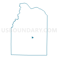
Freeman Tabernacle Bapt.Church, Lawrence County, Alabama
About
Outline

Summary
| Unique Area Identifier | 522265 |
| Name | Freeman Tabernacle Bapt.Church |
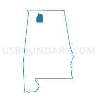
| County | Lawrence County |
| State | Alabama |
| Area (square miles) | 0.57 |
| Land Area (square miles) | 0.57 |
| Water Area (square miles) | 0.00 |
| % of Land Area | 100.00 |
| % of Water Area | 0.00 |
| Latitude of the Internal Point | 34.47183420 |
| Longtitude of the Internal Point | -87.27810490 |
Maps

Graphs
Select a template below for downloading or customizing gragh for Freeman Tabernacle Bapt.Church, Lawrence County, Alabama


Neighbors
Neighoring Voting District (by Name) Neighboring Voting District on the Map
- Moulton Armory, Lawrence County, AL
- Moulton Board of Education, Lawrence County, AL
- Pleasant Grove Church B, Lawrence County, AL